
CAPTAIN SEAGULLS CHART OFGPS18, NANTUCKET SHOALS TO MONTAUK
September 10, 2014CAPTAIN SEAGULLS CHART NG12, NANTUCKET SHOALS, GEORGES BANK
September 10, 2014
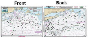
CAPTAIN SEAGULLS CHART GMM17, GULF OF MAINE & MASSACHUSETTS BAY CHART
$21.99
Offshore chart off 90 to 100 miles off coast, double sided, laminated, 19 x 26 inches, Maine, New Hampshire, and Massachusetts.
Front: The Gulf of Maine from Penobscot Bay to Boston, Massachusetts Bay, includes an inset of Portland Harbor, ME.
Back: Massachusetts Bay, Boston south to Provincetown and Duxbury, MA includes a bathymetric inset of Stellwagen Bank.
Use Bathymetric charts in conjunction with this chart, Jeffrey’s Ledge area is CA201, or Cashes Ledge & Stellwagen Bank, IC209.
Reviews
There are no reviews yet.